Rich HIstory
Conejos Country is located in the beautiful San Luis Valley.
There is evidence of human habitation dating back thousands of years. Archeologists have identified dozens of ancient sites throughout the valley. As recently as 200 years ago, and as far back as 11,000 years, nomadic Native American hunters came to Conejos County in search of food, shelter, and medicines. In those days, before grazing cattle and trophy hunters, tall grasses covered most of the valley floor creating a perfect home for many varieties of wildlife.
Word of the abundant and beautiful lands of North America reached Europe and by the mid 1500’s, exploration of this magnificent wilderness began. This resulted in centuries of uneasy and sometimes violent relations between Native Americans, who hunted seasonally in the valley, and the newcomers. In 1742 a group of Spanish livestock producers, farmers, trappers and miners petitioned the Spanish Crown for a land grant in what is known today as the San Luis Valley. Surrounded by majestic mountains and the headwaters of the Rio Del Norte, it was a desirable area in which to settle. Permanent settlement didn’t actually occur until the mid 19th Century. In 1851, the towns of San Luis and Guadalupe were established.
In the early 1800’s, current day Conejos County was in the possession of Mexico. In 1848, the war between Mexico and the United States was settled with the signing of the Treaty of Guadalupe Hidalgo. After the United States victory, the Conejos Land Grant became the territory of the U.S. When the territory of Colorado was created in 1861, the major part of the San Luis Valley was divided into two counties, Costilla County to the east and Guadalupe County to the west. Once the Colorado Territory was established, Guadalupe County was renamed Conejos County. Conejos, meaning rabbits in Spanish, was an apt name as the country was known for its abundance of rabbits. By 1870 there was a scattering of villages along the rivers and waterways of Conejos County. In 1877, Mormons, or Members of the Church of Latter Day Saints, arrived led by John Morgan. They settled in and around Manassa and Sanford. The relationship between the Hispano/Catholic and the Anglo/Mormon has always flavored the story of Conejos County as have the Native American, the Presbyterians, Mennonites, Syrian merchants, Jewish business men, Japanese, Swiss, Dutch, English, Irish and German farmers, ranchers, miners, and railroad builders.
Read moreIn the early 1800’s, current day Conejos County was in the possession of Mexico. In 1848, the war between Mexico and the United States was settled with the signing of the Treaty of Guadalupe Hidalgo. After the United States victory, the Conejos Land Grant became the territory of the U.S. When the territory of Colorado was created in 1861, the major part of the San Luis Valley was divided into two counties, Costilla County to the east and Guadalupe County to the west. Once the Colorado Territory was established, Guadalupe County was renamed Conejos County. Conejos, meaning rabbits in Spanish, was an apt name as the country was known for its abundance of rabbits. By 1870 there was a scattering of villages along the rivers and waterways of Conejos County. In 1877, Mormons, or Members of the Church of Latter Day Saints, arrived led by John Morgan. They settled in and around Manassa and Sanford. The relationship between the Hispano/Catholic and the Anglo/Mormon has always flavored the story of Conejos County as have the Native American, the Presbyterians, Mennonites, Syrian merchants, Jewish business men, Japanese, Swiss, Dutch, English, Irish and German farmers, ranchers, miners, and railroad builders.
Read more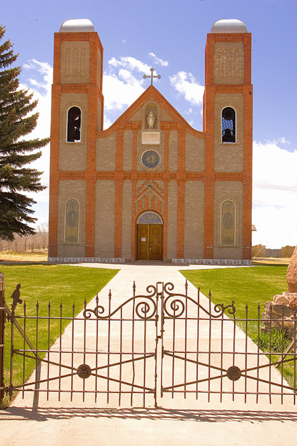
The village of Conejos boasts the oldest church in Colorado. Conejos County continues to be an ever-changing melting pot of cultures and perspectives. Although Guadalupe is considered the first established settlement (1851) in the county, other villages were being created at the same time. Guadalupe held the county seat until 1863 when its new neighbor, the town of Conejos, was established on the south side of the Conejos River.
Soon townspeople built a beautiful church and a large stone, three-story courthouse. The courthouse was in use until 1980 when, sadly, it burned to the ground. On the first year anniversary of the tragic fire, a brand new courthouse was built on the same site. Today, the town of Conejos still holds the county seat.
Spanish for “little Anthony”, Antonito was first called San Antonio Junction. Founded by the Denver & Rio Grande Western (D&RGW) Railroad in 1880, Antonito is located in the south central part of Conejos County. When the railroad was extending south from Alamosa, company officials failed to get the desired concessions at the old town of Conejos. So, they laid out a site of their own to the southeast of Conejos, and the first train pulled into Antonito the evening of March 27, 1880.
Since that time, the town has been a shipping center for the southern end of the San Luis Valley and northern New Mexico. For many years, it was the junction for two branches of the railroad, one west over Cumbres Pass into the San Juan country and Durango, and the other into the ancient capital of Santa Fe, New Mexico. The D&RGW closed the Chili Line to Santa Fe in 1941 because of competition from road transportation. Today, the San Luis and Rio Grande Railroad runs a freight train connecting perlite mine operations and lava rock to the north by hauling rail-cars loaded with these materials out of the area. The narrow gauge sections through the mountains are still in use as a historic tourist train.
Antonito lies just six miles north of the New Mexico state line. It sits between the Conejos and San Antonio rivers at an elevation of 7888 feet above sea level and is the gateway to the beautiful Conejos River Canyon. Antonito is well-known for its historic train, the Cumbres & Toltec Scenic Railroad. The town is the last full-service stop before heading up the Conejos River Canyon.
In 1880, as the D&RGW Railroad continued its southward expansion, it arrived at the La Jara Creek. At this halfway mark between Alamosa and Antonito, the railroad built a water tank, a small “section house” and a “sidetrack” or “siding”. Originally, this location was called The Tank. In 1880, foreseeing the advantage of a town near the railroad, a group of enterprising men made plans to establish a post office and a town.
They organized the La Jara Town Company and on April 18, 1884, the La Jara Town Company purchased the land surrounding The Tank from the State of Colorado. On July 15, 1884, a post office was established. The town of La Jara took its name from a Spanish settlement just downstream.
La Jara has developed into a small town full of activity. Today, it is home to the Conejos County Hospital, the Conejos County Library and Centauri Middle School and High School.
During the late part of the 19th century, a group of Mormon pioneers arrived from Utah to winter in Pueblo, Colorado. They traveled under the direction of leaders from the Church of Jesus Christ of Latter Day Saints. The earlier settlers began calling them Mormons because of their belief in the Book of Mormon. After spending a winter in Pueblo, the pioneers set out for the San Luis Valley. They finally settled in Los Cerritos where a number of Spanish and Indian families were already living.
The Mormon pioneers were not prepared for the hardships of frontier life. The Spanish families helped by giving food, teams of horses, mules, and cows. As was often the case in those days, survival depended on the generosity of good neighbors. While their own homes were being built a short distance away, the Mormons stayed with the Spanish families.
The Mormons created their own town, plotting out an area one-mile square with 64 ten-acre blocks with each block then being divided into four lots. The town was called Manassa after the biblical name Manasseh. Many residents of Manassa still operate farms and ranches that have been in their families for generations.
They celebrate Pioneer Days every year around July 24, honoring the anniversary of the Mormon Pioneers’ arrival to the Salt Lake Valley in Utah. The celebration includes two days of parades, barbeques, rodeos, carnival rides and dances.
The town is very proud of its pioneer heritage and particularly proud of its homegrown boxing champion, Jack Dempsey. Make sure to visit the Jack Dempsey Museum on Main Street. He will always be remembered as one of the world’s greatest sports giants.
This community was established in 1889 and named “Sunflower” because of the flower’s abundance. In 1901, a Denver developer mapped out Sunflower and renamed it Romero. Another town already had the Spanish name Romero, so the second “r” was dropped and the name became Romeo.
The Romeo State Bank, located in the Colonial Hotel Building was established in 1920. The Culler Store, Weddington Store, and the Romeo Store Company made up a good portion of the downtown. Most of the businesses in Romeo catered to farmers and ranchers. Just outside of Romeo, north on Highway 285 is a huge plaque honoring war veterans from the area.
The site of Sanford was surveyed in the fall of 1854 and named in honor of Silas Sanford Smith. He served as the first president of the San Luis Stake of Zion in Conejos County. The road between La Jara and Sanford was surveyed and improvements to the road were completed in 1935.
Sanford holds a Pioneer Day Celebration every July with a parade of beautiful floats made by local members of the Mormon churches. These floats are truly the highlight of the celebration. This is a quiet farming community, which is hard to find in our hustle-bustle world.
Spanish for “chokecherry”, it is named because of the chokecherry bushes that grow in the area. In 1867, Capulin became one of the first permanent settlements established by Spanish families. The Spanish settlement became a booming center of trade for its local citizens and area ranchers and farmers.
Present-day Capulin is very different from its early days. Paved roads replaced hard dirt, electricity replaced bees’ wax candles or kerosene lamps, and more modern homes replaced the adobe hacienda or modest adobe home. There are still remnants of the early Spanish-style home present today. Deteriorating cemeteries continue to serve as reminders of a proud pioneer past.